Menu Close

Field Books Map Search

Quick links      Field Books Home        Link 1: Properties       Link 2: Streets       Link 3: Maps       Link 4: Descriptions         Video Guide    

All the information on the 1910 Valuation Office Survey, the transcriptions, photos and maps are copyright from the National Archives at Kew. They may not be republished and they may not be used for commercial purposes.  See this link for full details https://www.nationalarchives.gov.uk/legal/copyright/

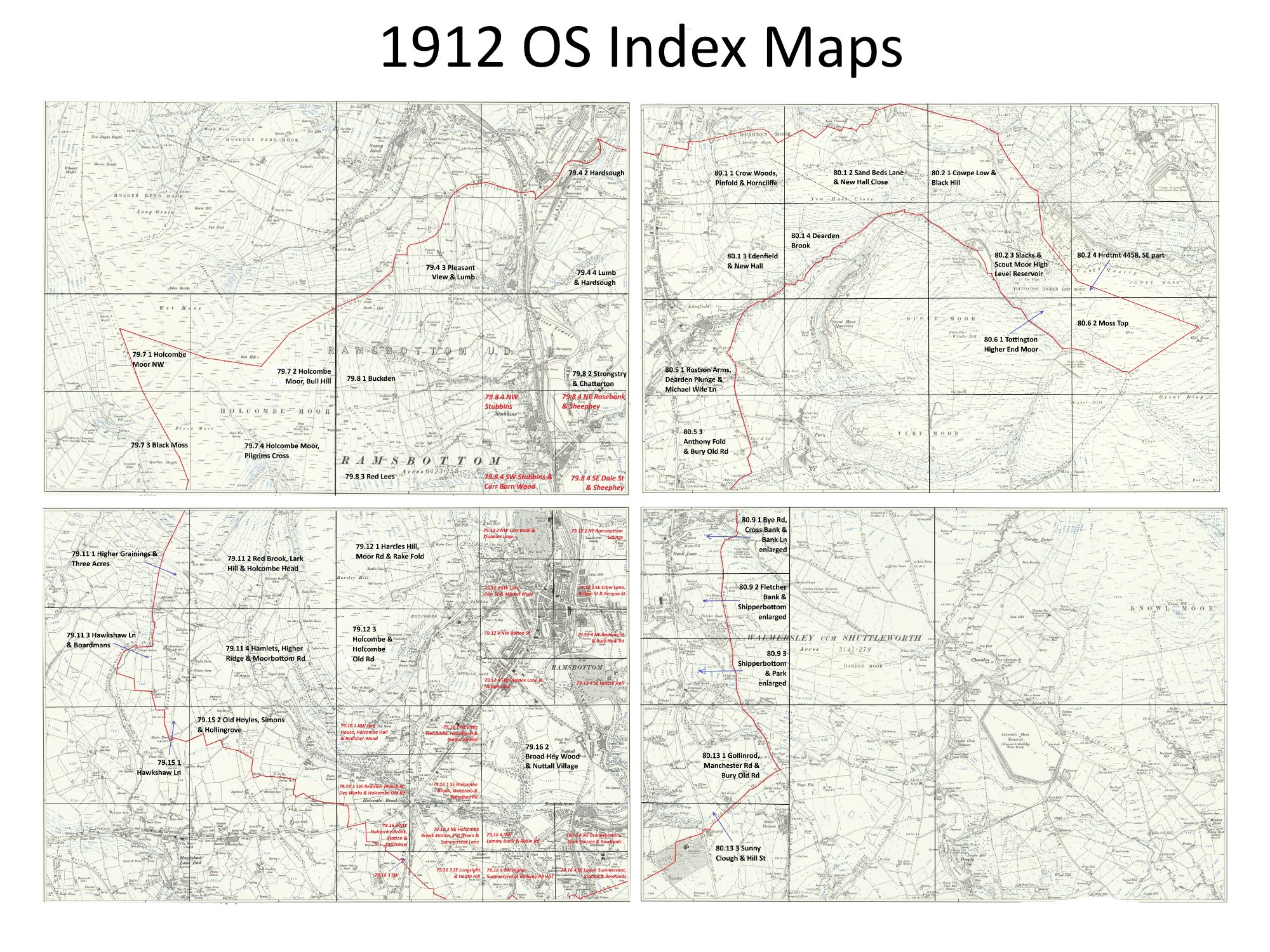
This image is the index to over 60 maps.  Hover over the image and a green box will show the area of the detailed map, and clicking will bring up the map.

Some of the areas on the edges of the Ramsbottom area, which is highlighted by a red line, do not have a map, but indicate which Income Tax Parish that the survey was a part of.

Each map has hereditament numbers in red, and from this number the Field Book can be deduced, i.e. Field Book 1 has numbers 1 - 100, 2 has 201 - 200, e.t.c so for example 2451 is in Field book 25

There are also enlargements of areas that cannot be shown on the map as they are underneath the Index Map. These can be acccessed via the following five links

Dale Street, Stubbins                 Holcombe Village             Nuttall Lane              Nuttall Village        Ramsbottom Town Centre (north of Bridge Street )

Hover over the maps and more detailed map desriptions will be shown as a green box, and clicking the box will load the map in a new window. There are over 60 maps and each map has the hereditament numbers in red. Areas of the map with no link to a map were not part of the Ramsbottom survey, which is highlighted on the image with a red border line

79.4 2 Hardsough 79.4 3 Lumb 79.4 4 Lumb and Hardsough 79.7 1 Holcombe Moor NW 79.7 2 Holcombe Moor, Bull Hill 79.7.3 Black Moss 79.7.4 Holcombe Moor, Pilgrims Cross 79.8 1 Buckden 79.8 2 Strongstry and Chatterton 79.8 3 Red Lees 79.8 SE 1 Stubbins 1250 Scale 79.8 SE 2 Rosebank & Sheep Hey 1250 Scale 79.8 SE 3 Stubbins and Carr Barn Wood 1250 scale 79.8 SE 4 Dale Street & Sheep Hey 1250 Scale 79.11 1 Higher Grainings and Four Ash 79.11 2 Red Brook, Lark Hill & Holcombe Head 79.11 3 Hawkshaw Lane & Boardmans 79.11 4 Hamlets, Higher Ridge & Moorbottom Road 79.12 1 Harcles Hill, Moor Road &Rake Fold 79.12 NE Town Centre North 1 Carr Bank and Stubbins Lane 1250 scale 79.12 NE Town Centre North 2 Ramsbottom Sidings 1250 scale 79.12 NE Town Centre N 3 Carr, Carr St and Market Place 1250 scale 79.12 NE Town Centre N 4 Crow La, Bridge St & Kenyon St 1250 scale 79.12 3 Holcombe & Holcombe Old Road 79.12 SE Town Centre South 1 Bolton St 1250 scale 79.12 SE Town Centre Sth 2 Railway Str & Bury New Rd 1250 scale 79.12 SE Town Centre South 3 Dundee Lane & Nuttall Lane 1250 scale 79.12 SE Town Centre South 4 Nuttall Hall 1250 scale 79.15.1 Hawkshaw Lane 79.15 2 Old Hoyles, Simons & Hollingrove 79.16 NW 1 Hey House, Holcombe Hill & Redisher Wood 1250 scale 79.16 NW 2 Little Holcombe, Hazelhurst & Bolton Road West 1250 scale 79.16 NW 3 Redisher Bleach & Dye Works & Holcombe Old Road 1250 scale 79.16 NW 4 Holcombe Brook, Waterloo & Woodhey Road 1250 scale 79.16 2 Broad Hey Wood & Nuttall Village 79.16 SW 1 Holcombe Brook, Station & Tittleshaw 1250 scale 79.16 SW 2 Holcombe Brook Station, Pot Green & Summerseat Lane 1250 scale 79.16 SW 3 Tittleshaw 1250 scale 79.16 SW 4 Longsight & Heath Hill 1250 scale 79.16 SE 1 Lammy Bank & Robin Road 1250 scale 79.16 SE 2 Brooksbottom, Brick Houses & Rowlands 1250 scale 79.16 SE 3 Higher Summerseat & Railway Road West 1250 scale 79.16 SE 4 Lower Summerseat, Station & Rowlands 1250 scale 80.1 1 Crow Woods, Pinfold & Horncliffe 80.1 2 Sand Beds Lane & New Hall Close 80.2 1 Cowpe Low & Black Hill 80.1. 3 Edenfield & New Hall 80.1 4 Dearden Brook 80.2 3 Slacks & Scout Moor High Level Reservoir 80.2 4 Hereditament no 4458 SE part 80.5 1 Rostron Arms, Dearden Plunge & Michael Wife Lane 80.6 1 Tottington Higher End Moor 80.6 2 Moss Top 80.5 3 Anthony Fold & Bury Old Road 80.9 1 Bye Road, Cross Bank & Bank Lane 80.9 2 Fletcher Bank & Shipperbottom 80.9 3 Shipperbottom & Park 80.13 1 Gollinrod, Manchester Road & Bury Old Road 80.13 3 Sunny Clough & Hill Street Haslingden Income Tax Parish Haslingden Income Tax Parish Bacup Income Tax Parish Walmersley Income Tax Parish Tottington Income Tax Parish Walmersley Income Tax Parish 79.8 4 Chatterton

Haslingden Income Tax Parish

The names of the Income Tax Parishes adjacent to Ramsbottom are shown though their maps have not been copied.

Haslingden Income Tax Parish

The names of the Income Tax Parishes adjacent to Ramsbottom are shown though their maps have not been copied.

Bacup Income Tax Parish

The names of the Income Tax Parishes adjacent to Ramsbottom are shown though their maps have not been copied.

Walmersley Income Tax Parish

The names of the Income Tax Parishes adjacent to Ramsbottom are shown though their maps have not been copied.

Tottington Income Tax Parish

The names of the Income Tax Parishes adjacent to Ramsbottom are shown though their maps have not been copied.

Walmersley Income Tax Parish

The names of the Income Tax Parishes adjacent to Ramsbottom are shown though their maps have not been copied.


Quick links      Field Books Home        Link 1: Properties       Link 2: Streets       Link 3: Maps       Link 4: Descriptions         Video Guide